![](/images/other/stat-length.png)
![Randonnée Marche Le Puy-en-Velay - Puy en velay - St Privat d'Allier - Chemin de Compostelle - Photo](https://media.geolcdn.com/t/1900/400/ext.pjpeg?maxdim=2&url=https%3A%2F%2Fservices.sitytrail.com%2FGeolivesWS%2FDownloadMedia.ashx%3FTrailID%3D108145%26Media%3D198_6.jpg)
Puy en velay - St Privat d'Allier - Chemin de Compostelle
tracegps
Utilisateur
![Longueur](/images/other/stat-length.png)
![Altitude max](https://static1.geolcdn.com/siteimages/upload/files/1508320355ic_sort_altitude_max_24dp.png)
![Dénivelé positif](https://static1.geolcdn.com/siteimages/upload/files/1508320355ic_sort_den_pos_24dp.png)
![Km-Effort](/images/other/stat-length.png)
![Altitude min](https://static1.geolcdn.com/siteimages/upload/files/1508320355ic_sort_altitude_min_24dp.png)
![Dénivelé négatif](https://static1.geolcdn.com/siteimages/upload/files/1508320355ic_sort_den_neg_24dp.png)
![Boucle](https://static1.geolcdn.com/siteimages/upload/files/16400158638029165_repeat_loop_refresh_sync_direction_icon.png)
![Marche](https://static1.geolcdn.com/sitytour/trail-icons/101.png)
6h04
Difficulté : Très difficile
![Scannez ce code QR pour ouvrir la randonnée dans l'application SityTrail](https://capi.geolives.com/qq0zvz2zws4bq2lad0pu/sitytour/trails/108145/qr.png?size=200)
Application GPS de randonnée GRATUITE
À propos
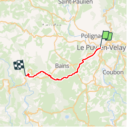
Randonnée Marche de 24 km à découvrir à Auvergne-Rhône-Alpes, Haute-Loire, Le Puy-en-Velay. Cette randonnée est proposée par tracegps.
Description
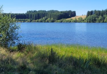
Cette étape du Chemin de Compostelle est longue de 24,5Km avec une dénivelée d'environ 580m. La sortie du Puy en un peu raide pendant 4.6km (230m de dénivelée) mais reste très facile. Les 13.8Km suivants sont montant mais on ne le sent pas (270m de dénivelée) tant le pourcentage est faible. Puis arrive la montée au lac de l'Oeuf, dernière difficulté de l'étape, 100m de dénivelée sur 1.3Km, c'est quand même pas insurmontable bien que les kilomètres de la journée commencent à se sentir. Le reste du parcours en en descente soutenue jusqu'à St Privat (350m de dénivelée sur 4.7Km). D’autres informations et photos sur le Chemin de Compostelle sont disponibles ICI Balade proposée par « Les Balades et Randonnées de Fred »
Localisation
Commentaires
Randonnées à proximité
![Randonnée Marche Le Puy-en-Velay - Compostelle : 1-Le Puy en Vely - St Didier d'Allier - Photo](https://media.geolcdn.com/t/375/260/ext.jpg?maxdim=2&url=https%3A%2F%2Fservices.sitytrail.com%2FGeolivesWS%2FDownloadMedia.ashx%3FTrailID%3D211858%26Media%3Dfix__20130728164656.jpg)
![Marche Marche](https://static1.geolcdn.com/sitytour/trail-icons/101.png)
Marche
![](/images/other/stat-length.png)
![](https://static1.geolcdn.com/siteimages/upload/files/16400158638029165_repeat_loop_refresh_sync_direction_icon.png)
![Randonnée Marche Le Puy-en-Velay - Le Puy Saugue Avril 2018 - Photo](https://media.geolcdn.com/t/375/260/ext.jpg?maxdim=2&url=https%3A%2F%2Fservices.sitytrail.com%2FGeolivesWS%2FDownloadMedia.ashx%3FTrailID%3D954919%26Media%3D2e3e85fe-c058-45c1-9a8a-a4a30709daad.JPG)
![Marche Marche](https://static1.geolcdn.com/sitytour/trail-icons/101.png)
Marche
![](/images/other/stat-length.png)
![](https://static1.geolcdn.com/siteimages/upload/files/16400158638029165_repeat_loop_refresh_sync_direction_icon.png)
![Randonnée Marche Le Puy-en-Velay - Compostelle 5 GR65 - Photo](https://media.geolcdn.com/t/375/260/ext.jpg?maxdim=2&url=https%3A%2F%2Fstatic1.geolcdn.com%2Fsiteimages%2Fupload%2Ffiles%2F1553511878bg_sport_marche.png)
![Marche Marche](https://static1.geolcdn.com/sitytour/trail-icons/101.png)
Marche
![](/images/other/stat-length.png)
![](https://static1.geolcdn.com/siteimages/upload/files/16400158638029165_repeat_loop_refresh_sync_direction_icon.png)
![Randonnée Vélo électrique Le Puy-en-Velay - 130824 **** - Photo](https://media.geolcdn.com/t/375/260/fdfbbe51-5566-4838-83f0-e36bbf1f6406.jpg&format=jpg&maxdim=2)
![Vélo électrique Vélo électrique](https://static1.geolcdn.com/sitytour/trail-icons/205.png)
Vélo électrique
![](/images/other/stat-length.png)
![](https://static1.geolcdn.com/siteimages/upload/files/16400158638029165_repeat_loop_refresh_sync_direction_icon.png)
![Randonnée Marche Le Puy-en-Velay - 1 Stevenson Le Puy en Velay - Le Monastier sur Gazeille - Photo](https://media.geolcdn.com/t/375/260/c209631a-08c0-4975-b143-c32a8ede5982.jpg&format=jpg&maxdim=2)
![Marche Marche](https://static1.geolcdn.com/sitytour/trail-icons/101.png)
Marche
![](/images/other/stat-length.png)
![](https://static1.geolcdn.com/siteimages/upload/files/16400158638029165_repeat_loop_refresh_sync_direction_icon.png)
![Randonnée Marche Chaspinhac - Chaspinhac - Photo](https://media.geolcdn.com/t/375/260/ext.jpg?maxdim=2&url=https%3A%2F%2Fstatic1.geolcdn.com%2Fsiteimages%2Fupload%2Ffiles%2F1553511878bg_sport_marche.png)
![Marche Marche](https://static1.geolcdn.com/sitytour/trail-icons/101.png)
Marche
![](/images/other/stat-length.png)
![](https://static1.geolcdn.com/siteimages/upload/files/16400158638029165_repeat_loop_refresh_sync_direction_icon.png)
![Randonnée Marche Polignac - Polignac - Photo](https://media.geolcdn.com/t/375/260/ext.jpg?maxdim=2&url=https%3A%2F%2Fstatic1.geolcdn.com%2Fsiteimages%2Fupload%2Ffiles%2F1553511878bg_sport_marche.png)
![Marche Marche](https://static1.geolcdn.com/sitytour/trail-icons/101.png)
Marche
![](/images/other/stat-length.png)
![](https://static1.geolcdn.com/siteimages/upload/files/16400158638029165_repeat_loop_refresh_sync_direction_icon.png)
![Randonnée Vélo électrique Le Puy-en-Velay - Barrage de lavalette - Photo](https://media.geolcdn.com/t/375/260/2c58ac6e-8e36-4295-955d-493cd4ba7e8e.jpg&format=jpg&maxdim=2)
![Vélo électrique Vélo électrique](https://static1.geolcdn.com/sitytour/trail-icons/205.png)
Vélo électrique
![](/images/other/stat-length.png)
![](https://static1.geolcdn.com/siteimages/upload/files/16400158638029165_repeat_loop_refresh_sync_direction_icon.png)
![Randonnée Vélo électrique Le Puy-en-Velay - Le puy en Velay \ Lac de Malaguet - Photo](https://media.geolcdn.com/t/375/260/943eed4d-44d6-4147-96b1-0a97d186c094.jpg&format=jpg&maxdim=2)
![Vélo électrique Vélo électrique](https://static1.geolcdn.com/sitytour/trail-icons/205.png)
Vélo électrique
![](/images/other/stat-length.png)
![](https://static1.geolcdn.com/siteimages/upload/files/16400158638029165_repeat_loop_refresh_sync_direction_icon.png)
première étape Saint Jacques. Très bien.